ISRO Releases IRNSS Interface Control Document to Jumpstart Commercial Applications
19 September 2014

Indian Space Research Organization (ISRO) has released the Signal-in-Space Interface Control Document (ICD) for Standard Positioning Service (SPS) for the Indian Regional Navigation Satellite System (IRNSS). Currently under development, the IRNSS constellation will serve as India’s domestic Global Navigation Satellite System (GNSS). The first two of seven satellites, IRNSS 1A and IRNSS 1B were launched in 2013 and 2014 respectively.
The Signal-in-Space ICD for SPS provides information for research and development purposes to facilitate commercial applications for the satellites.
IRNSS is designed to provide a Standard Positioning Service (SPS) and a Restricted Service (RS). Once completed, it is expected to provide position data with accuracy of better than 20 meters in India — the primary service area. The constellation will also cover 1,500 km outside the country for extended regional coverage.

IRNSS-1A is the first satellite in the Indian Regional Navigation Satellite System (IRNSS). It is one of the seven satellites constituting the IRNSS space segment.
Payloads - IRNSS-1A carries two types of payloads navigation payload and ranging payload. The navigation payload of IRNSS-1A will transmit navigation service signals to the users. This payload will be operating in L5 band (1176.45 MHz) and S band (2492.028 MHz). A highly accurate Rubidium atomic clock is part of the navigation payload of the satellite. The ranging payload of IRNSS-1A consists of a C-band transponder which facilitates accurate determination of the range of the satellite. IRNSS-1A also carries Corner Cube Retro Reflectors for laser ranging.
Applications of IRNSS
Physical
Dimensions 1.58 metre x 1.50 metre x 1.50 metre
Orbit Geosynchronous, at 55 deg East longitude with 29 deg inclination
Power Two solar panels generating 1660 W, one lithium-ion battery of 90 Ampere-Hour capacity
Propulsion 440 Newton Liquid Apogee Motor, twelve 22 Newton Thrusters
Control
System Zero momentum system, orientation input from Sun & star Sensors and Gyroscopes; Reaction Wheels, Magnetic Torquers and 22 Newton thrusters as actuators
Mission Life 10 years
Launch date Jul 01, 2013
Launch site SDSC SHAR Centre, Sriharikota, India
Launch
vehicle PSLV - C22

IRNSS-1B is the second dedicated navigation satellite of India. It is one of the seven satellites constituting the IRNSS space segment. Its predecessor, IRNSS-1A, was launched by PSLV-C22 in July 2013. IRNSS-1B has a lift-off mass of 1432 kg. The configuration of IRNSS-1B is similar to that of IRNSS-1A. The satellite has been realised in less than seven months after the launch of its predecessor.
Payloads - IRNSS -1B carries two types of payloads - navigation payload and ranging payload.The navigation payload of IRNSS-1B will transmit navigation service signals to the users. This payload will be operating in L5 band (1176.45 MHz) and S band (2492.028 MHz). A highly accurate Rubidium atomic clock is part of the navigation payload of the satellite. The ranging payload of IRNSS-1B consists of a C-band transponder which facilitates accurate determination of the range of the satellite. IRNSS-1B also carries Corner Cube.
Lift-off Mass 1432 kg
Physical
Dimensions 1.58 metre x 1.50 metre x 1.50 metre
Orbit Geosynchronous, at 55 deg East longitude with 29 deg inclination
Power Two solar panels generating 1660 W, one lithium-ion battery of 90 Ampere-Hour capacity
Propulsion 440 Newton Liquid Apogee Motor, twelve 22 Newton Thrusters
Control System Zero momentum system, orientation input from Sun & star Sensors and Gyroscopes; Reaction Wheels, Magnetic Torquers and 22 Newton thrusters as actuators
Mission Life 10 years
Launch date Apr 04, 2014
Launch site SDSC SHAR Centre, Sriharikota, India
Launch vehicle PSLV - C24
The Signal-in-Space ICD for SPS provides information for research and development purposes to facilitate commercial applications for the satellites.
IRNSS is designed to provide a Standard Positioning Service (SPS) and a Restricted Service (RS). Once completed, it is expected to provide position data with accuracy of better than 20 meters in India — the primary service area. The constellation will also cover 1,500 km outside the country for extended regional coverage.
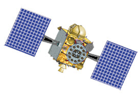
IRNSS-1A

IRNSS-1A is the first satellite in the Indian Regional Navigation Satellite System (IRNSS). It is one of the seven satellites constituting the IRNSS space segment.
Payloads - IRNSS-1A carries two types of payloads navigation payload and ranging payload. The navigation payload of IRNSS-1A will transmit navigation service signals to the users. This payload will be operating in L5 band (1176.45 MHz) and S band (2492.028 MHz). A highly accurate Rubidium atomic clock is part of the navigation payload of the satellite. The ranging payload of IRNSS-1A consists of a C-band transponder which facilitates accurate determination of the range of the satellite. IRNSS-1A also carries Corner Cube Retro Reflectors for laser ranging.
Applications of IRNSS
- Terrestrial, Aerial and Marine Navigation
- Disaster Management
- Vehicle tracking and fleet management
- Integration with mobile phones
- Precise Timing
- Mapping and Geodetic data capture
- Terrestrial navigation aid for hikers and travelers
- Visual and voice navigation for drivers
Physical
Dimensions 1.58 metre x 1.50 metre x 1.50 metre
Orbit Geosynchronous, at 55 deg East longitude with 29 deg inclination
Power Two solar panels generating 1660 W, one lithium-ion battery of 90 Ampere-Hour capacity
Propulsion 440 Newton Liquid Apogee Motor, twelve 22 Newton Thrusters
Control
System Zero momentum system, orientation input from Sun & star Sensors and Gyroscopes; Reaction Wheels, Magnetic Torquers and 22 Newton thrusters as actuators
Mission Life 10 years
Launch date Jul 01, 2013
Launch site SDSC SHAR Centre, Sriharikota, India
Launch
vehicle PSLV - C22
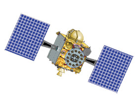
IRNSS-1B

IRNSS-1B is the second dedicated navigation satellite of India. It is one of the seven satellites constituting the IRNSS space segment. Its predecessor, IRNSS-1A, was launched by PSLV-C22 in July 2013. IRNSS-1B has a lift-off mass of 1432 kg. The configuration of IRNSS-1B is similar to that of IRNSS-1A. The satellite has been realised in less than seven months after the launch of its predecessor.
Payloads - IRNSS -1B carries two types of payloads - navigation payload and ranging payload.The navigation payload of IRNSS-1B will transmit navigation service signals to the users. This payload will be operating in L5 band (1176.45 MHz) and S band (2492.028 MHz). A highly accurate Rubidium atomic clock is part of the navigation payload of the satellite. The ranging payload of IRNSS-1B consists of a C-band transponder which facilitates accurate determination of the range of the satellite. IRNSS-1B also carries Corner Cube.
Lift-off Mass 1432 kg
Physical
Dimensions 1.58 metre x 1.50 metre x 1.50 metre
Orbit Geosynchronous, at 55 deg East longitude with 29 deg inclination
Power Two solar panels generating 1660 W, one lithium-ion battery of 90 Ampere-Hour capacity
Propulsion 440 Newton Liquid Apogee Motor, twelve 22 Newton Thrusters
Control System Zero momentum system, orientation input from Sun & star Sensors and Gyroscopes; Reaction Wheels, Magnetic Torquers and 22 Newton thrusters as actuators
Mission Life 10 years
Launch date Apr 04, 2014
Launch site SDSC SHAR Centre, Sriharikota, India
Launch vehicle PSLV - C24
23.03.2015


