Holux introduces touch-screen bike computer with u-blox which supports GPS as well as GLONASS, QZSS and all SBAS
8 September 2014

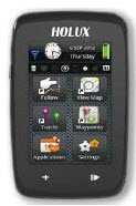
Holux Technology, a maker of professional and consumer GPS products, has launched its next-generation bike computer, the SporTrek 1305, which integrates a u-blox MAX GPS/GNSS module. The new device delivers state-of-the-art global positioning and wireless health-monitoring features on a compact, 3-inch color touch screen display. The device delivers a variety of useful information such as speed, heart rate, distance, altitude, map, route, calendar and stop-watch. SporTrek 1305 is the perfect companion for touring, competitive cycling and mountain biking.
The device integrates a compact u-blox MAX GPS/GNSS module which supports GPS as well as GLONASS, QZSS and all SBAS. The module is targeted at applications requiring small size, low power, fast acquisition, and reliable operation in GPS hostile environments.
“Since 1994, Holux has been manufacturing a wide range of battery-operated GPS products for sports, automotive and safety devices. We count on extremely fast, low-power and accurate global positioning technology to deliver the features our customers demand,” said Eddy Huang, Director, Marketing & Sales at Holux, “u-blox’ advanced satellite positioning module provides us with the performance, small size, and low power consumption that we need in a consistent, future-proofed form factor.”
The SportTrek 1305 is shock and water resistant able to operate in all weather conditions. Equipped with Bluetooth Smart for accessories (such as heart-rate straps…etc.), it can also connect to Heart-Rate Monitor / Combo (Speed & Cadence) Sensors and Smartphone connection and notification, providing navigation and performance training data.
It also integrates a patented “Carbon Reduction” feature that informs the user about the amount of equivalent carbon emissions saved as compared to driving, and converts the data into the corresponding number of trees planted to achieve the same effect.
SporTrek 1305 can be integrated with ezTour Plus software to share track route and analysis of physical states, and it can also be used to plan routes using the ezTour Planner feature. Users can integrate their own paper maps and 3rd party application as well.
Press releas
24.09.2014


